My Street
 3 Beautiful Hiking Trails near Rimetea and Coltesti villages – Transylvania, Romania

We are in Transylvania, the famous region of Romania.
Villages like Rimetea, Coltesti, Izvoarele & Valisoara are nestled here, in the Trascaului mountains. Well known in our country for thee traditional architecture of the houses and for the picturesque surroundings.
We’ve hiked the most beautiful trails that you can find in this area. Medium difficulty, amazing views. Just a little bit of easy rock scrambling on 2 particular points but nothing to be afraid of. It can be done with your dog also (we’ve taken our Belgian Malinois).
The mountains here are not very high, the maximum altitude on the 3 proposed routes is 1129m on top of Piatra Secuiului (hike no.2). They compensate with scenic views. Limestone walls emerge from green meadows. Wildlife is still present in their woods so it will be no surprise if you spot at least a deer during this hikes.
The trip was on New Year’s Eve and first days of January . We didn’t had any snow. It was more like an autumn feel as you will see in the video:
Hike no.1: Data Mountain and left side of Valisoarei Gorges
Map, altitude profile and .gpx track file download from here https://www.bikemap.net/en/r/7873721/ or from here https://www.strava.com/activities/4548003314
The 10 km took us 4 hours to complete it (2h55min actual moving time). Around 650 m total climb.
We started right from our accommodation (Holiday House Valisoara) but you can begin at any specific point that’s convenient to you. The route has a red dot marking almost the entire way (excepting the proximity of our accommodation where we were out of the normal track). It’s quite easy to navigate, the path was well marked. I would recommend you to do it in the same clockwise direction as we did. This way you climb Data mountain first and leave the Valisoarei Gorges at the end.
The first part is quite easy, initially on a dirt road and then on the brown autumn meadows that lie beneath Data mountain.


Climbing Data mountain requires a little bit of easy rock scrambling, there are also some iron wire installed at some point for better safety. Nice panorama over the entire area.
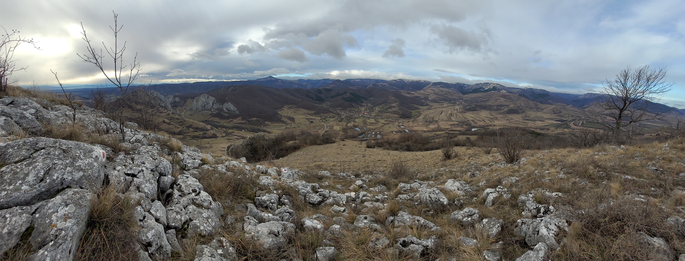
Once the climb done, the rest of the track gets easier heading over the left side of the Valisoarei Gorges. The views are impressive all the way.


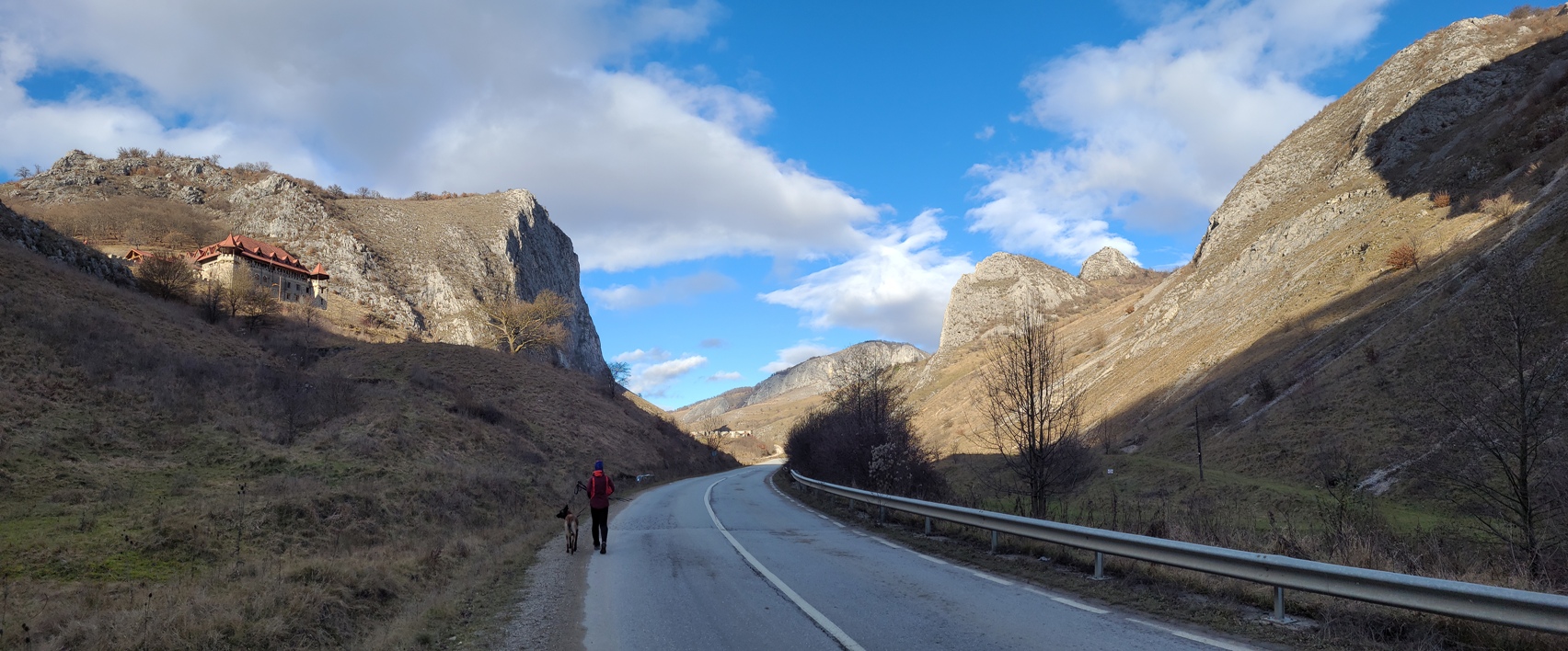
The final decent takes you to the paved road that passes through the gorges.
Hike no.2: Piatra Secuiului Coltii Trascaului
Map, altitude profile and .gpx track file download from here: https://www.bikemap.net/en/r/7873784/ or from here: https://www.strava.com/activities/4544979782
The 8 km took us 3h30min to complete (2h47min actual moving time). Around 670 m total climb.
The starting point is right in the center of Rimetea village, near the Ethnographic Museum which i definitely recommend you to visit also.There is also a big panel with all the hiking routes of the area.


We didn’t had luck with the weather, it was cloudy unfortunatelly. I belive that in good weather views are a lot nicer.
The climbing starts right from the start. Blue cross marking. The path gets quite steep and rocky until the very top of Piatra Secuiului. The peak is overlooking the village so when you reach it you will stand on the edge of a huge precipice. It so worth all the effort to get there.
Climb also the second peak, Coltii Trascaului, for a different perspective than descent the forest path on the red line marking all the way to Rimetea.


Hike no.3: Valisoarei Gorges right side
Map, altitude profile and .gpx track file download from here: https://www.bikemap.net/en/r/7873804/ or from here: https://www.strava.com/activities/4554377830
The 7 km took us 3 hours to complete (2h10min actual moving time). Around 450 m total climb.
Red dot marking all the way. You start from the paved road of Valisoarei Gorges. We did it counterclockwise so there is a long and steep, forest path, climb at the beginning, until you reach the first peak. It should be somehow easier to do it clockwise but than you will have a steep, slippery forest descent if it rained the days before…. your choice.
There is also a small cave at the beginning, with a interesting rock window through which you can see Data mountain (the one from hike no.1). If you start early in the morning it will be gorgeously illuminated by the sunrise. First top of the day, Bogza Mare, reveals you the magnificent landscape bellow.


The rest of the route takes you through the forest until you reach Bogza Mica peak. It is only now, from this spot, that you really get to see the size and beauty of the gorges:


Visit also the Coltesti Fortress
Start from the center of the Coltesti village. Blue line marking. You should reach it in about 1 hour of easy walking.